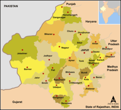
Rājputāna, meaning "Land of the Rajputs",[1]was a region in India that included mainly the present-day Indian state of Rajasthan, as well as parts of Madhya Pradesh and Gujarat,[1]and some adjoining areas of Sindh in modern-day southern Pakistan.[2]

The map of the Rajputana Agency in 1909

Districts of the present-day state of Rajasthan
The main settlements to the west of the Aravalli Hills came to be known as Rajputana, early in the Medieval Period.[3] The name was later adopted by British government as the Rajputana Agency for its dependencies in the region of the present-day Indian state of Rājasthān.[4] The Rajputana Agency included 18 princely states, two chiefships and the British district of Ajmer-Merwara. This British official term remained until its replacement by "Rajasthan" in the constitution of 1949.[4]


टिप्पणियाँ
एक टिप्पणी भेजें